
[vc_row][vc_column][vc_text_separator title=”Services”][vc_column_text]
Our Data Information and Technology (DI&T) is a special division of TRDA. This division provides a variety of especially innovative services that have a significant effect on the economy, agriculture, public health, economic development, sustainability, resiliency, and long-term survivability for communities, companies, and nations. Other services are not listed and discussed only with a potential client. This is because what we offer is truly unique.
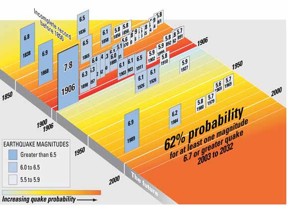
Our services forecast long-term climate, stock-market viability, and hazards-rupture predictions for earthquakes and volcanoes. For example, we forecast earthquakes within a specific time window, a geographic location (currently within 60 epicenter), and magnitude (currently a range). The goal of this service is to be within a 10-day time window, within 30 miles of the epicenter, and a specific magnitude. This is done without nested data arrays.
Other forecast(s), specifically climate, can be done at the local to nation scale and provide what we like to call “the crystal-ball effect” because the forecasts are not for days or weeks as most companies and agencies provide, but in many cases, up to 7 years. Imagine the ability to determine when the next major earthquake will happen, how long the next drought will last and its impact, when the stock market may plummet, or when the next major terrorist attack will occur. What would you do with such information? Would it help your community, company, or nation have greater resiliency and sustainability? That potential is here now!
[/vc_column_text][/vc_column][/vc_row][vc_row][vc_column][vc_text_separator title=”Partial List of services as Single Components”][vc_column_text]
- Climate Forecasts
- Flood Forecasting
- Earthquake Rupture Forecast (location, period, and magnitude)
- Stock-Market Fluctuations
- And, more
[/vc_column_text][/vc_column][/vc_row][vc_row css=”.vc_custom_1508990021564{margin-bottom: 25px !important;}”][vc_column][vc_text_separator title=”Approach”][vc_column_text]
 Our DI&T approach is not based only on current data, but inclusive of past data, extreme pattern recognition, coupling of extensive modeling and mathematical processes and quantification of industry experiences, as well as a proprietary technology to help prepare the best for future hazards of all types that can cause disruption in continuity of management or government. Along with the services comes an extensive economic and physical effects, as well as forecasted hazard(s) effect(s) and much more. Included in this approach is an assessment and analysis of resiliency and sustainability to a national scale.
As an example of our approach to problems, one of the reasons our experts modeled the entire Mississippi River Basin (the fifth largest in the world at 3.4M square kilometers) was due to such basin’s great geopolitical importance, as well as to help us understand conflicts and potential cooperative measures to resolve them, especially regarding transboundary issues and disputes. The allocation of water resources within river basins is a critical to sustainability and resiliency long term, especially if transboundary issues are a concern in which the water in the basin is a shared resource, which can easily become a source of tension. This is happening globally today, from the Colorado River System in the Western United States to the Indus River System Pakistan and India, to the Golan Heights in Israel bordering Jordan. River basins are inherently complex systems with many interdependent components (aquifers, canals, cities, farms, irrigation districts, reservoirs, streams, etc.). The sustainability of a region or country’s future economic growth and environmental health in a river basin depends on the rational allocation of water among the basin riparian’s (users sharing the basin’s water resources) and sectors (municipal, industrial, agricultural, and environmental, and others).
The principal sources of many transboundary rivers lie in mountainous states where water may be regulated by a cascade of reservoirs for various purposes such energy production and where there are competing users for the water, such as agricultural in downstream countries. For example, the Syr Darya basin in Central Asia. Particularly in these cases, the issues of river basin management are international, and policy solutions often require regional cooperation among the concerned riparian countries. If a basin is wholly contained within one country, locally optimal allocation of water to economically efficient uses may be a good solution. However, within transboundary basins, where countries exert their (limited) sovereignty over water resources within their territorial borders, solutions for sharing those resources can be difficult if not impossible. In transboundary cases, the water allocated to a country by agreement between the basin riparian’s becomes an upper limit on water available for that country. The allocation of that water share within the country is, by and large, a domestic policy issue while the allocation of shares between countries is an international issue faced by all the basin riparian’s.
In many cases, downstream countries do not have local water sources, but they have developed significant irrigated lands for which they must rely on upstream countries for water supply. Examples include the Danube, Nile, Indus, and Aral Sea basins, as well as others. An upstream country’s goal in river-basin management may be to maximize hydroelectric power production, which could conflict with the downstream country, whose goal may be to maximize the utilization of water for irrigated agricultural production. Often the temporal characteristics of the goals of upstream and downstream countries in a basin may lead to international water-management problems. For instance, upstream peak-power demand may occur in an opposite cycle to downstream countries such as winter versus summer. In such a case flows change greatly due to agricultural and other uses. Without cooperation, these situations can lead to international conflict over the shared waters of a basin.
River basin models have been used to aid in the determination of fair and equitable long-term water sharing agreements or short-term operational plans in transboundary basins. A river basin model is a mathematical model that represents the relevant processes in a river basin and can predict the behavior of the basin under different conditions or management scenarios. These models help decision-makers from the basin states understand the ramifications of different water allocation scenarios and operational regimes and the corresponding benefits to themselves and their neighbors. They can be used to understand the trade-offs between water releases made for one use (say, agricultural production) versus those made for another (say, hydroelectric power generation).
As an example, consider a transboundary basin where an upstream country’s water management goal is power generation and a downstream country’s goal is irrigation water supply. Making releases for power generation in the winter will not allow saving that water for summer release for irrigation. The following scenarios could be considered by the different countries for this situation:
Upstream country:
- Maximize power generation in the upstream country over the planning period; or
- Minimize power deficits in the upstream country in winter months over the planning period.
Downstream country:
- Maximize water supply for agriculture and other uses in the downstream country over the planning period.
Therefore, upstream, and downstream scenarios could be in direct conflict, which is why our forecasting for multiple years at a time is helpful – accurate knowledge of the resource can help attempt to satisfy different management objectives for potential cooperative solutions to water management in the basin. Such results would include deficits of water for irrigation as well as deficits of power delivered under the different management scenarios, which would include drought occurrence, project use and other scenarios. Economic valuation of the water uses (agricultural production, electricity generated, municipal users served, etc.) can also be evaluated. This is especially helpful to model the uncertain nature of regional climate, various flow sequences, and normal, dry, and wet years.[/vc_column_text][vc_row_inner][vc_column_inner width=”1/2″][vc_single_image image=”354″ img_size=”full” alignment=”center”][/vc_column_inner][vc_column_inner width=”1/2″][vc_single_image image=”353″ img_size=”full” alignment=”center”][/vc_column_inner][/vc_row_inner][/vc_column][/vc_row][vc_row bg_type=”bg_color” css=”.vc_custom_1508990817688{margin-bottom: 25px !important;padding-top: 25px !important;padding-right: 25px !important;padding-bottom: 25px !important;padding-left: 25px !important;}” bg_color_value=”#eeeeee”][vc_column][vc_text_separator title=”Business Development & Execution”][vc_column_text]
Our DI&T division covers cross-cutting interdependencies of hazards such as droughts, flooding, earthquakes, and more with their effects on Science & Technologies relevant to global, homeland, and national security and business issues, which include many and that key on resiliency and sustainability. Examples include water, energy, food, commodity supply lines, and other key resources, public policy, critical infrastructure, and cascading effects of regional and country-scale proportions of complex hazards and systems. We merge these areas in terms of cascading failures and forecasting, vulnerabilities, risk, operational resiliency, and continuity of operations from local to global scales.
With crises at almost every turn in more chaotic environments, the information we provide can help alleviate or mitigate problems before they arise thus, reducing stress and increasing sustainability.
DI&T senior managers are world-class practitioners with advanced degrees and over 70 years of experience in their respective fields. For each assignment, we select the most appropriate process and team to deliver a product that other firms cannot currently match. So, if you are concerned about all hazards, from mapping human behavior to drought forecasts to earthquake predictions, contact us.
[/vc_column_text][/vc_column][/vc_row][vc_row][vc_column][vc_text_separator title=”Current Investigations & Analysis”][vc_single_image image=”342″ img_size=”full” alignment=”center”][/vc_column][/vc_row][vc_row][vc_column][vc_column_text]
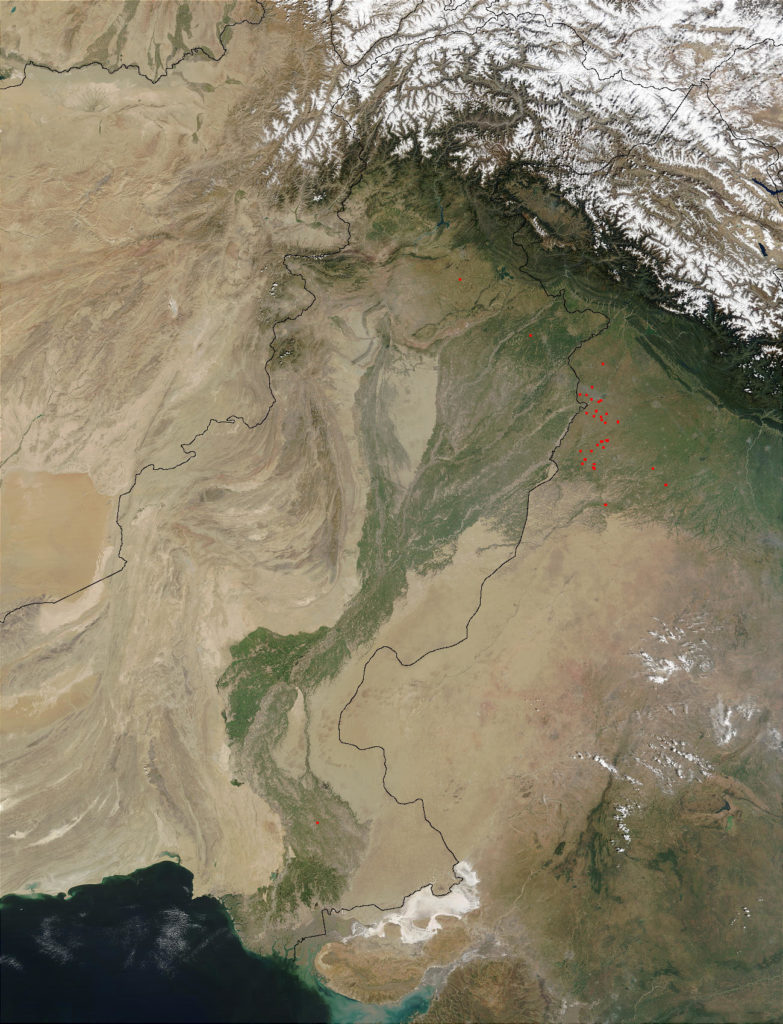
Indus River System: Geopolitics, Flow, and More
Background: China-India-Pakistan Transboundary Water Issues
Water-security issues threaten China’s basic national interests. Increasing drought conditions in some parts of China and disparate distribution of water resources, as well as economic interests and international political pressure are beginning to frame the Chinese government’s position on this issue. Both the quantity and distribution of water throughout the country and its neighbors, including Pakistan, India, and Southeast Asia, represent significant challenges to China’s future. Since the end of the last ice age, Himalayan glaciers have been melting; along with increasing population, it is anticipated that long-term declines in water availability will occur, as has been happening recently. The goal to maintain economic growth at about eight percent annually is threatened by water-security issues. Melting glaciers that provide a large amount of water to China’s rivers and those of Southeast Asia are experiencing water-flow variability; other issues related to water quantity are also occurring, including desertification and salt-water intrusion along some coastal areas, which threaten both economic sustainability and food production. The Mekong River and fragile border regions along Northern Pakistan are demanding increased geopolitical communication with these neighbors, which are far from cordial.
China has been diverting water from sources originating in Tibet to aid their own water shortages which in turn leaves other neighboring countries with less water flow from source. One conflict (between China, Pakistan and India over the Indus River) has been aptly named ‘war at the top of the world.’ Can China and its neighbors manage the water problems within themselves or will it escalate into a form of the Jordan River conflicts between Israel and its neighbors, which resulted in war?
Many Asian nations are already under some form of water stress that minimally threatens economic sustainability from the individual fisherman to the country level, and the Asian continent, due to population, has the lowest per-capita water allocation of all continents excepting Antarctica. As an example, in northern China, water use compared to availability is about four times the level in the south, i.e., water availability in northern China is much less than in Southern China. Unfortunately, northern China is where most of the factories that keep China’s economic engine running were built. China’s large size and proximity to ocean and desert regimes causes extreme cyclical climate change events and thus, disparate water distribution from severe droughts in the north to extreme flooding in the south. The extreme variability has increased soil degradation, resulting in desertification creep in the north and erosive soil loss in the south, resulting in loss of agricultural production. These climatic extremes are expected to increase maximum monthly flows along the Mekong river basin by 35 to 40 percent; minimum monthly flows are expected to decline by 17 to 24 percent. This significant flux change will threaten and could disrupt economic and agricultural activity in the most vulnerable regions of the Mekong basin due to increased flooding during the wet season and less available water during the dry season. Additionally, coastal regions in these vulnerable areas could experience salt-water intrusion due to fresh water draw-down, resulting in greater effects on agricultural production.
Without the occurrence of another ice age that formed the Himalayan glaciers, they will continue to melt, analogous to tossing an ice cube onto the floor in the middle of a room, until the glaciers are gone, even without increasing global temperatures. Unfortunately, glacier melt accounts for about 70 percent of the summer flow in the Ganges river systems and about 60 percent of the flow in other major Asian river systems such as the Brahmaputra. Inevitably, glacier flow will cease, resulting in catastrophic water shortages and extremely severe transboundary water-security issues that will likely lead to mass civil unrest, widespread starvation through reduced agricultural production, and war. Knowing the potential beforehand, how would policy among the transboundary water sharing countries avert these conditions? China’s water and transboundary issues affect many countries, as illustrated below, including Afghanistan, Pakistan, India, and all of Southeast Asia. It should be noted that both Pakistan and India are nuclear armed.
The Tarim River, as an example, which is Xinjiang’s most important river system depends on glacial melt for about 40 percent of its annual flow and will likely be heavily impacted by seasonal flow variability. Overall, water distribution patterns, particularly related to precipitation, will likely become much more variable. The water-related issues will clearly spill over China’s borders, especially in the major rivers and their systems, including the Indus, Ganges, Brahmaputra, Irrawaddy, Salwan, and Mekong. The major transboundary conflicts are likely to occur in relation to the Ganges, Indus, and Mekong rivers, affecting Bangladesh, India, and Pakistan, and Laos/Thailand/Cambodia, respectively.
Since the late 1990s China has begun addressing both environmental and social issues through better cooperation and dialogue as a part of their new security concept and initiative, especially due to the destabilizing nature of water within China and on its neighbor states, which could potentially lead to conflict like that in the Middle East. As early as 2008, China began better agreements with its neighbors and signed an agreement with the government of the Russian federation concerning reasonable utilization and protection of transboundary waters that specified the scope, contents, and methods of bilateral cooperation, as well as providing legal foundations for further cooperation.
Despite cooperative efforts with other countries regarding transboundary disputes, China’s very survival, particularly its economic sustainability, is increasingly threatened by its water-security and water supply issues. About 23 percent of its population lives in western regions where glacial melt provides the principal dry season water source. This continually diminishing resource will create a growing competition among users. As water supplies grow scarcer there is the possibility of migration from scarce resource areas to more plentiful resource areas, resulting in unrest, possible ethnic tensions with the Han minority in western China, job loss and public health issues. During 2008-2009 in northern China, the worst winter drought in 30 years occurred, which affected about 40 percent of China’s winter wheat crop. As with many countries facing resource shortages, a greater emphasis has been placed on disaster management and response capabilities, much of which will likely fall on China’s military, analogous to what the U.S. has done with its National Guard.
Transboundary issues are only a part of China’s water problems. The Yangtze River flows in China from Qinghai Province to the East China Sea and geographically separates North China and South China. It supports approximately one third of China’s population and is the main water supply for agriculture, representing almost half of China’s crop production. Additionally, analogous to the Mississippi in the U.S., the Yangtze serves as the major navigable waterway in China. It binds the inland and coastal ports together with other major cities into a transportation network in which Nanjing, Wuhan, and Chongqing are major hubs. The Yangtze River is also the main water supply for the industrial sector, with a recorded 40 percent of the country’s industrial output through both the Gezhou Dam and the Three Gorges Dam.
The river is a crucial lifeline that secures sustainable socio-economic development. The Three Gorges Dam, built across the Yangtze, helped to increase China’s electricity supply, making it more affordable, and helped to control catastrophic floods, thereby boosting agricultural production and the economy. The Three Gorges Dam has undergone much controversy; however, “It is necessary … for the sake of the long-term stability of the national economy as a whole and the safety of the lower and middle reaches of the Yangtze,” said Wan Li, chairman of the National People’s Congress, China’s nominal Parliament (1992). A report by the United States Department of Defense stated the dam would be a prime target for China’s enemies because of the value the dam holds and the destruction of the dam from an enemy standpoint would be an easy way to win a war with China. Other countries view the Chinese Dam projects as indirect deadly weapons, and if the Chinese continue their attempts to dam or redirect the southward flow of river waters from the Tibetan plateau, a war against South Asia is likely. In May 2007, the Asian Development Bank and Asia-Pacific Water Forum stated, “the majority of Asia’s water problems are not attributable to an actual shortage, but rather are the result of poor water governance.” This is only partially true as there generally is poor water governance throughout the world at large, but substantially it over simplifies the problem. At the 7th Asian Security Summit in June 2007, the Minister of Defense, based in Singapore, Teo Chee Hean, said, “Asia acknowledges the growing international water tensions and national conflicts, but, instead of competing over water, or food, or energy, we can increase our collective security by cooperating to harness alternative energy sources and increase food supply; while looking ahead, we need to build capacities that are capable of accommodating different modes of cooperation between different configurations of countries.”
Within and without, China has enormous water-security concerns for which solutions will be hard fought and complex.
The Indus River and China’s Neighbors — Pakistan and India
The Indus River starts in Tibet, China, and flows through India and Pakistan, ending at the Arabian Sea (see graphic above courtesy of NASA); the river stretches 1,976 miles with the final flow entering the Arabian Sea at an approximate flow rate of 207 billion cubic meters annually. The Indus River is the main water supply to millions of people of China, India, and Pakistan. Water shortages in China, Pakistan, Nepal, Bangladesh, and India are driven by distribution patterns, population increases, and economic growth. This river has a history of conflict that is continuing to escalate. Dams and water diversions have been built along the Indus River to provide power and irrigation to provinces, but downstream users are experiencing decreasing supply, increased pollution, population displacement, and ecosystem destruction.
Water is the key component to survival. The Indus River has been an area of conflict between China, Pakistan, Nepal, Bangladesh, and India for centuries. The use/overuse of water, territorial claiming of water resources, damming, and water distribution are resulting in water conflicts. An example of water’s importance is the 1948 dispute between India and Pakistan as the two countries were formed out of one big land mass, giving no defining water boundaries for either country. As a result, India stopped all water sources within its territory that were flowing into Pakistan. Pakistan, being down river from India, “was hit hard by the water shortage with enormous loss in energy sector and agriculture-related businesses, in addition to imminent food inflation. Instead of military retaliation, the Indus Water Treaty was formed to alleviate water conflicts by giving both countries control of three rivers from Jammu and Kashmir. However, despite efforts from the International Law Association implementing the Dubrovnik rules leading to the Helsinki Rules, conflicts have continued. Disputes between Pakistan and India have continued; in 1984, India built the barrage on the Jhelum River at the mouth of Wullar Lake and then, in 1992, the Baglihar Dam on the Chenab River; these, along with many more instances have maintained a constant tension between the two countries. And, because the headwaters of the Indus begin in Tibet, there is growing tension between three nuclear armed neighbors regarding these transboundary disputes. As water quantity diminishes, the trend of damming water resources continues as does the fight to control and profit from water resources. Depending on water shortage severity, the Indus Water Treaty is in jeopardy of failing.
China’s water-related issues will continue to put pressure on the country, especially economically, as well as require additional focus on foreign relations and political discourse relating to transboundary issues and national security. Specific regions such as the Mekong, Indus, and Ganges, will likely be more severely impacted with time regarding water stress, and being transboundary in nature will likely strain the capacity of Chinese institutions and policy frameworks. Not only does China’s economic sustainability depend upon its water resources and water security, its national security will be in jeopardy in event of severe water stress, forcing greater cooperation or potential hostility with its surrounding neighbors and even the U.S. because of strategic concerns over water and food security, along with economic sustainability.[/vc_column_text][/vc_column][/vc_row]